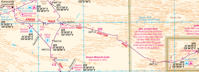
We don't need fuel yet fortunately as it is $3.40 per litre here at the Kunawirritji Community. Pleasant spot here. Lots of Zebra Finches again and a lone Dingo (at least we only saw one). Had a chat to some of the other campers. One backpacker was stuck here after destroying a universal on the Canning. He's waiting for the part to be sent to the Kunawirritji Community and apparently is able to use their workshop for the repair. Doesn't know how to do the job but he's going to Google it!! Had a shower and washed our hair and then filled up with water from the bore. There was a tap at the tank that the windmill pumped into, however, the transfer to the camper was very slow and we ended up borrowing Arthur's pump, letting the water run into a bucket and pumping the water from the bucket into the camper's tanks.
Back to the Wapet Road and then a short time on the Jenkins Track before heading east on the Gary Junction Road. Len Beadell and the Gunbarrel Road Construction Party built this road in 1960 and has been named after his son. Len put lots of markers up along his tracks and the first of these was at the beginning of the Gary Junction Road (and the intersection of the Gary Junction Road and the (so-called) Gary Highway which travels north/south. Many are replicas these days and here the original (1963) was replaced with a replica in 2004.
As we were driving along the Gary Junction we noticed blue spots (looked like they had been sprayed with an aerosol can) about every 20m along the verge of the road. About every 400m there was a stake in one. A bit further along the road, we came across orange power cables being thrown from a truck. This plus junction boxes went on for 50 kilometres. We stopped at a truck and asked about it. Apparently, they are doing seismic testing for minerals - covering 1,000km along the road and doing 50km at a time. A little further along we came across the machinery doing the actual seismic testing.
The track varies in condition but considering our isolation is pretty good. At one stage we passed through some uplifted country with a spectacular lookout with views over the countryside. Some interesting rock formations, weathered in all sorts of shape. Like most Australian deserts the Great Sandy Desert (which we are crossing) is dry but you wouldn't call it desolate. (Or is it the Gibson Desert - we're pretty much in between the two).
Camp tonight is at Jupiter Well (or to be more accurate near Jupiters well. The original Jupiter well is 200m to the south of the road. Just to the north of the road is the "new" Jupiter Well with a hand pump that has been constructed in more recent times. We're camped a little further in off the road among the desert oaks. The original Jupiter well was constructed by the National Mapping survey team in 1961 and meant that water no longer needed to be carted from Mt Liebig, 430 km to our east - named Jupiter Well as when it was dug, the reflection at night looked like Jupiter.
Plenty of firewood and a glorious moon.


